
It’s Saturday morning and we are underway for home. Pandora is moving along pretty well, hard on the wind as we move toward our first waypoint to enter the Gulf Stream near Cape Canaveral.
The plan is to stay out of the Stream until tonight as the wind is still pretty strong from the northwest, which will kick up some pretty big and short seas in the Stream. I spoke with Chris Parker today and he forecasts that the NW wind will drop away tonight, and stay that way for several days, which will allow the Stream to calm down and make for a reasonable passage probably with the help of our engine. Fortunately, we have 150 gallons of fuel in the three tanks and an extra 20 in jugs so we should have plenty to make the run all the way home, assuming that we don’t have to push hard into the wind at an unusually high RPM. Given the forecast, that’s not too likely.
The current in the Stream is pretty strong here, running in the 3-4kt range in a generally northerly direction which means that we would get quite a boost toward home once we are in it’s current.
Right now, at Chris’s recommendation, we are staying west of the current so as to avoid the very steep and confused waves caused by the wind against current in the Stream. Once the wind dies tonight we will jump in to take maximum advantage of the current.
While there will be wind for much of our trip, it’s going to be generally behind us and in the range of 10-15 knots which isn’t quite enough to sail in as we will be heading in the same direction of the wind. That means that the “apparent wind”, the wind speed minus our speed in the same direction, will be less than we need to carry a good speed.
If the wind was on our tail and blowing more like 20kts, we’d be in pretty good shape. Let’s hope that the wind is a bit stronger, but not too strong, than forecast.
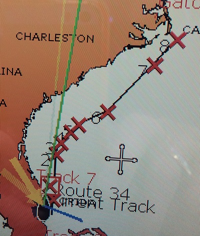
Chris also gave me the coordinates for the center of the Gulf Stream from Cape Canaveral to Cape Hatteras, where we will exit the Stream as we head for Montauk at the eastern end of Long Island and home.
Just for fun, here’s a shot of my plotter showing how the stream meanders up the east coast. As you can see, it comes very close to Cape Hatteras, the part that juts out in the upper left, so you can see how this can cause conditions to be very rough there and particularly so when the wind is from the NE. That’s why “nor’easters” off of Hatteras are so feared.
Anyway, this will be our rough course over the next few days. I would hope that we’d be able to cover the roughly 500 miles between us and Cape Hatteras by Monday or so.
While it’s a long way off, a fairly strong cold front is expected to make it’s way through New England around Sunday the 15th so it would be best if we were home by that point. If not, we’ll have to find somewhere to hide till conditions improve.
Well, we are on our way and for now, that’s my report.
Stay tuned and let’s hope that we make a rapid passage.
One response to “Heading North Toward Home”