Sail Pandora

Uncategorized

Yes, another day following the “ditch” south.

It’s Friday late morning and we have been underway since 07:00 on our way to Carolina Beach NC.   The run today should be somewhat shorter than the last two days, which have both been between 70 and 80nm.   As I write this we are about 45nm from our destination which should put us there at a reasonable hour.

This morning it was raining lightly as we headed out and the sunrise was quite stunning. The goal for today is to put us near Cape Fear where we will jump out behind a cold front which is supposed to exit the coast there around mid-day Saturday for our 250nm run to St Mary’s, a run that should take us about a day and a half.  The wind is expected to be pretty strong, and from behind us, for perhaps as much as 24 hours and then it will become much lighter.   All of this suggests that we will have to motor-sail for at least part of the time.  However, we will surely make much better time, and hopefully sail for a good while, than being in the ICW. Hopefully, the winds will remain behind us and not go toward the south until we make port in St Mary’s 

As has been the case lately, it continues to be hard to get a weather window that lasts more than a few days which really makes it difficult to do any long offshore passages.  This wouldn’t be a problem if I was just cruising down the coast, but with a deadline to get home and a need to make time. it does make things a bit tricky.

When Brenda and I did this run two years ago, we had all sorts of time and really never had to worry about a schedule, which was nice.  Last year, I was able to make a run all the way from Beaufort some 600nm to Ft Pierce FL in a single shot as we had a pretty good window. However, that run was quite dramatic as it was on the tail of a very strong cold front that brought us winds of up to 40kts on the tail.  Actually, for my taste, that was a bit too much to be pleasant.  However, we did make good time.

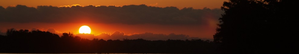
Yesterday we saw our first dolphins as well as some pelicans.  I have had a really tough time getting shots of dolphins but was able to get a shot, even if it’s a bit blury.  Also, the pelicans weren’t very close.  However, it is a photo of a pelican and they say that blogs are better with photos, even crappy ones (editor’s assumption).  I guess you’ll have to be the judge.  Judge “nicely” please…  This is probably a photo that screams “you had to be there”.Today’s run takes us through Camp Lejeune, a major Marine base.  The ICW goes right through the camp area and there are some intimidating signs along the way to warn you when they are conducting live fire exercises.   Two years ago Brenda and I anchored in a small harbor within the camp’s boundaries and near us was a huge concrete ramp that provided access to the waters for hovercraft.  We didn’t see any during our visit but others have told me that it’s pretty amazing when the marines come blasting through on one of the big hover craft as they blast down the dirt road and into the water, throwing salt spray everywhere.

I guess that this sign suggests that they aren’t kidding.Yesterday we were passed at high speed by some really impressive powerboats manned by marines and painted in grey camouflage.   The boats, about 40’ long, were very angular looking, probably designed to be less detectable by radar.  Unfortunately, they came by so fast that I wasn’t able to get my camera out in time to get a shot.  I suspect that that’s the idea.

A few minutes ago we were passed by an Osprey VTOL aircraft, that’s “Vertical Take Off and Landing”.  These are sort of a high-bred of a prop plane crossed with a helicopter.  Their huge rotors are vectored vertically for takeoff and then are rotated forward to fly like a regular plane.  The design has been plagued by problems from the start, with quite a few crashes over the years but continue to be in service.   Never the less, they look amazing flying by.  Too bad they didn’t get closer.   I guess you’ll have to use your imagination.  No wait, I cropped it.  That’s not too bad.  Yes?The waterway here is flanked by miles of marsh grass on both sides.  The color of the grass is quite dramatic against the overcast sky.  Like the other canals on the ICW, this area is carved out of swamp and the channels go on for miles without a bend. Shrimping is big business in these parts.  This guy passed us in really narrow channel with his nets set out to dry.  A very impressive sight.  It looked like some sort of massive insect.  Well, it’s time for lunch so I had better wrap it up.  Hopefully, the weather will hold out for our run, beginning on Saturday.  

Moving down the ICW toward our planned offshore run to St Mary’s

It’s Thursday morning and we are motoring down the ICW near Oriental, NC.  The winds are very calm with just enough on the beam to allow us to motorsail, sort of.  It’s a beautiful area in a bleak sort of way.

Last night we anchored in Belhaven NC, a town that some might say has “seen it’s best days” many years ago.  The main street has a number of empty storefronts, which is a bit depressing.   The land is VERY low with the streets near the water not more than a few feet above sea level.   I can’t imagine what a storm surge from a hurricane would do to the area.  Can you say “mom, there’s 8’ of water in the garage, no wait, in the living room”.  Yikes…

Jim and I went ashore for pizza and beer and were very pleased with how good the pizza was.  I wasn’t expecting much and was pleasantly surprised.  There is a new restaurant in town that was about to open up when Brenda and I were there last October and I was impressed with how nice it was. Given the look of mainstreet, the place looked a bit out of place.  However, even on a Wednesday night they seemed to be doing a pretty good business.   The place is called The Tavern at Jack’s Neck.  It’s worth visiting.

So, here we are motoring toward Beaufort and our plan to make an offshore run, perhaps beginning on Saturday. However, the dilemma is that the window for a good offshore breeze is pretty short and I am not sure if there is enough time to make the 360 mile run from Beaufort to St Mary’s GA before the wind clocks to the south and stops our progress.

In the fall, winds from the north are common but they seem to only last for a few days prior to clocking back to the prevailing southerly direction.  The problem is that this doesn’t allow enough time to make a long run offshore.  Anyway, today I was thinking about this and it occurred to me that perhaps the best option would be to bypass Beaufort NC, which is just south of Cape Hatteras and head another 80-100 mile south from there and jump out at either Masonboro Inlet, just north of Cape Fear or to continue a bit further to Cape Fear River Inlet and jump out from there.  By heading out from Cape Fear, we can avoid the 40 mile SE run to get around the Cape Fear shoals that would be required if we headed out from Masonboro Inlet.

I suspect that we will be able to make the additional distance down the ICW to Southport NC in time to catch the favorable winds in the Cape Fear area that should arrive late on Saturday.

Anyway, that’s the plan, for today anyway, which should put us into St Mary’s in time to make our Wednesday evening flights home.

Yesterday and today will be long days but the motoring is easy with very light winds and glass calm conditions.  Yesterday we were underway for over 11 hours and made nearly 80 miles.  That was a long but very pleasant day.  Today is likely to be about the same.  The shore scenery as we headed down narrow canals was a bit bleak but pretty at the same time.  I guess you’ll have to be the judge. Very peaceful.A few minutes ago two mean looking bunch of GI Joe guys in RIBS blasted by.  They were hauling.  Your tax dollars hard at work.   And, what’s a post without a nice sunrise over downtown Belhaven in a light haze.The beginning of yet another beautiful day on the ICW.  We’ll see how the plans go.  For now, continuing to mosey on down the ICW.    

And, that’ s my report.

Day one on the ICW and well on our way to Beaufort NC.

It’s Wednesday morning and we left Elizabeth City around 07:30 to make the run to Belhaven, about 70 miles south on the ICW.   We had a very nice visit in EC last night and enjoyed a terrific dinner of boiled spicy shrimp that we peeled and ate in the cockpit and washed down with a few beers.   We also had some terrific crabcakes, dusted with Old Bay seasoning and coleslaw on a bed of lettuce.   Mmmm…

As we were preparing to head out today, we were treated to a wonderful sunrise over the waterfront park in Elizabeth City.  Pandora’s on the right. Nice place.This morning Ken  left Pandora to drive home as our run was taking more time than he had to commit to the trip.  As his schedule was really tighter than we both realized, it was unlikely that he’d be able to do the whole trip anyway. 

However, my other crew member, Jim knows the boat pretty well now having sailed with me from Nassau to Essex last year.  Actually, by the time we get to St Mary’s GA next week, he will have been aboard Pandora for more miles than anyone else who has crewed with me in to date.  He’s a pleasure to have on board.

So, we decided to make a long day today on our run to Belhaven and will be underway till early evening.

A nice view of downtown Elizabeth City as we left this morning.  The water was glass smooth. As we head south, we are making a good 7kts which is good.  Interestingly, when I left LI Sound Pandora’s bottom had not been cleaned for about a month and the best speed that I was able to get with 2,000 RPM was only about 6.4kts.  Now that I have gone all the way to Annapolis and now down to North Carolina, we are doing a bit over 7kts with the same RPM.  That suggests that the light slime that had built up on the bottom has been worn off by the passing water.

Speaking of speed, I am particularly pleased with my new Autoprop as I am getting nearly 1.5kts better speed at the same RPM.   I checked the fuel economy the other day and determined that we are now getting better fuel economy at about .77GPH versed just under a gallon per hour, and going the same speed.  That translates into a MPG of about 8.5 as opposed to something like 6.5 with my old prop.  I’ll need a bit more time to confirm that number, but it seems about right.  I was told that I would see about a 15% improvement in fuel economy with the new prop, and this seems to confirm that.

Yesterday was a wonderful day as we made our way through the Dismal Swamp Canal from Newport News.   The canal is an impressive engineering feat dug by slave labor during George Washington’s time.  Slavery is indeed an unfortunate part of our history and the canal is one example of the hardships that these people endured.  I am pleased that the canal has been kept up for all of these years as a reminder of our past.

Here’s the sunrise just below the lock.  Beautiful and very peaceful.On a positive note, one of my favorite parts of the trip is seeing the Lock Tender Robert, as we enter the north lock of the canal. Robert is always good for a smile and warm greeting.   And this time, he even shared a Danish and cup of coffee with us.  What a great guy.   As if that wasn’t enough, he even agreed to do a “short” conch concert.  I hope to upload the clip soon but don’t have the bandwidth to do it right now.  You go Robert!!!Transiting the lock to the canal is a wonderful experience as we were lifted the 8’ to the swamp and then dropped down again at the other end.   Doesn’t Pandora look right at home in the lock?Ken enjoying a cup of Robert’s coffee.  Note the wall above Pandora. Now, in the full position, 8’ higher.  An impressive rise in only a few minutes.Pandora looking good in the lock and ready to go.On our way down the canal.  So smooth and peaceful. I guess that I’d better focus on where Pandora’s going and less on where she’s been.  Don’t want to run aground.  No wait, Jim’s at the helm.  Whew…

Oh yeah, I spoke with Chris Parker today and it looks like we will get some favorable winds to jump out of Beaufort for the 2 day sail to St Mary’s, perhaps on Saturday.  Fingers crossed.  I’ll talk to him again on Friday morning.  Wish us luck.

That’s all for now.

Weather window? Hatteras, here we come. Maybe not.

It’s Monday morning and the sun is just peaking up over the eastern horizon as we make our way into Hampton Rhodes after an overnight from the Rhode River near Annapolis.  The sky is overcast but quite dramatic.  I tried to time the shot when the lighthouse was blinking.  No luck…The weather was unremarkable for our overnight run, with virtually no wind.  All we got was a light shifting 5kts from a variety of directions.  No wind.  Not so good.  Glass like conditions.   However,  really good for an easy run under power.

I certainly prefer to sail over motoring, but it’s nice to just turn on the motor and point toward where we need to go.  That’s particularly appealing when you are in busy shipping channels such as in Chesapeake Bay, which we were, that’s for sure.

As we headed down the bay, beginning mid afternoon yesterday, we were constantly being passed by ships come up and down the bay, some as large as nearly 1,000’.  It’s pretty impressive to see a cruise ship steam by, lit up like a city building.  No wait, these monsters are city buildings, or at least a large town, but one that floats.

In spite of all the traffic, the night was pretty uneventful (that’s good) with a lot of time spent keeping track of ships on AIS, the “automatic identification system” that all ships have on board and we monitor aboard Pandora.  This system transmits their speed and direction and that information is interpreted by my chart plotter to give me a display of CPA “closest point of approach” and other information regarding each ship that is quite useful.

In particular, the name of the ship is noted which makes it easy to call them by name.  In the past, when I called a ship, noting their general location only, I didn’t usually get a response.  Now, knowing where they are and how close they will be to me, perhaps in 20 minutes, takes a lot of the anxiety out of the picture.  It’s great to be able to talk to them on the radio and get an immediate answer and advice as to how to stay out of harm’s way.  That’s really great, calming actually. .

In the past, prior to AIS, you had to look at the lights and try and interpret what they were going to do and scramble out of the way, whatever I was able to determine was the way they were going.  At night, this was pretty difficult.  Much better now, that’s for sure.

Much of last night was pretty mundane but the highlight for me was when I spied a tug on AIS that was approaching from the south.  The name displayed was something like “Tug Jim” or other such mundane name.  However, the AIS system also tells you where they are going, such as Baltimore, for example.  In this case, the signal designated their destination as “The Hell if I know”.    I wonder what the US Coast Guard would think of that.  Hmm…  I guess “Jim” has a sense of humor.

Anyway, we are now tied up at a dock at the Hampton Yacht Club and are enjoying a day of rest while we wait for the weather off of Cape Hatteras to clear up, if perhaps only briefly.   I spoke to Chris Parker yesterday and again today and his advice is to time our arrival at Hatteras for around dawn on Wednesday.  That suggests a departure from here early on Tuesday morning.

NO WAIT…  Here’s another idea.  With the short weather window to get around Hatteras and all the anxiety that goes with that, let’s just bag it and go through the Dismal Swamp Canal.  I like that idea…

Ok, so, after much debate (in my mind anyway), as I finish this post, we are motoring down to Norfolk where we will go out to dinner and a movie and then leave in the morning to head INSIDE, the easy way, to Beaufort and then a combination of outside and the ICW to GA.  There are also crew considerations in all of this and one of my guys has to leave prior to GA so going inside this way makes a lot of sense.  Besides, the weather window we need to make the run to GA may very well close before we get there and, well, let’s just say that I got a headache thinking of all the possibilities and just decided to bag the whole thing and go inside.

And, to top it all, this is supposed to be fun and I just love the run from Newport News to Beaufort and the Dismal Swamp Canal.

Yes, that’s what we are going to do.  And, that route will make for some fun posts.

Stay tuned.

Heading to GA this week, I’m pretty sure…

It’s Sunday morning early and Pandora is at Camp Letts near Annapolis MD.  For the last two days I have been attending the SSCA Gam here and enjoying time with some 350 other cruisers for a meeting with seminars and speakers on all sorts of topics.  Actually, it’s amazing just how many folks I recognize in the group.  

This gam, upon which the one we modeled our Essex June event, is one of several that the Seven Seas Cruising Association, SSCA, does throughout the year.

The event is located at Camp Letts, a Boy Scout camp just south of Annapolis on the Rhode River.   As the event has grown over the years, to it’s present size, with some 300-400 attendees, they have outgrown most locations that might house them and certainly the ones that they can afford, given the low cost of the events that they try to put on to attract cruisers.  The location is quite a beautiful setting with great views of the harbor from 180 degrees.

The speakers were quite good with talks by Chris Parker, the weather router that we use, as well as talks about proper rigging of a boat for offshore passages, how to set up a boat to “live off the grid”, safety and where to go when you cruise.   All and all, a great group of speakers.

It was good to see Chris Parker in person again as I speak with him on the radio off and on and get his updates on the weather nearly every day.   I also wanted to remind him of the plans we have in Essex as he has agreed to speak at our meeting.  He’s a very good speaker and teacher.

I am particularly interested in what Chris has to say about the weather coming up this week as I will be making my way down the coast toward St Mary’s GA where she will be hauled till Brenda and I join her in early January.

As the warm weather of summer battles it out with the colder weather of winter, the big question is if there will be the northerly winds that we need to head south.  I really have no interest in banging my head against unfavorable winds, and am willing to wait for winds that will get us there quickly and comfortably.

Based on his preliminary assessment yesterday at the meeting, admittedly, without his computer models, he thinks that we will be able to get a window to head out around Cape Hatteras, mid-week to make out way toward GA.   This suggests that we should make our way down the bay toward Hampton VA  at the mouth of the Chesapeake Bay after the meeting today or first thing in the morning and wait a few days for the favorable winds to come through.

One thing that looks certain is that there is going to be a band of squally, nasty, weather in the waters off of Hatteras Tuesday and going out into the middle of that would not be a good idea.

At this point, the question will be if we should wait in Hampton and go out and around Hatteras, or if we should go in at Hampton,  make our way down the ICW, Intra Coastal Waterway, inside to Beaufort while the adverse conditions off of Hatteras work themselves out.   As that inshore route is protected,  we can do it even if the weather isn’t so great.  Outside, in the ocean, the conditions are exposed and it would not be a good idea to head out until things settle down.   The problem with the inside route is that we can only move during daylight hours, making the trip from Hampton to Beaufort a three to four day trip verses a much shorter offshore run as we can continue moving 24/7.

Such are the questions that I have to answer to be sure that we can make a good and safe run to GA from here, a run of about 600 miles and to get there in decent time.  My crew, Jim and Ken, whom have sailed with in the past, won’t be too keen on sailing aboard Pandora in the future if we have a nasty, unpleasant run.

To get the latest forecast, I will call Chris today on the phone and talk to him to get the forecast as he does not broadcast on Sunday.

Fingers crossed that things will play out as hoped and we will be on our way today or Monday.

Perhaps I’ll close with a nice shot of today’s sunrise to prove that it was pretty early when I wrote this.  What a peaceful spot to write.Oh yeah, I should also use the photo that Brenda took of me waiting for the train looking like a Sherpa.   Well at least like a serious “mini sherpa” ready to climb a large mountain.  You know, you can never have enough lines aboard.   I ended up replacing my main sheet and jib sheet with two of these. I was hoping that I looked mean enough to raise the conductors suspicion.  Alas, no such luck.  Well at least, if the train was to get stuck on a bridge I could have used them ro repel down to safety.  Yeah, right…  As always, I’ll be posting Pandora’s position on “where’s Pandora” as we wake our way down the coast over the next week.   I am optimistic that things will go well. 

Scroll to Top